


SkyDemon
default
SkyDemon ၏ ရွင္းလင္းခ်က္
SkyDemon VFR လေယာဉ်စီမံကိန်းနှင့် In-လေယာဉ်သွားလာမှုများအတွက်ဥရောပရဲ့လူကြိုက်အများဆုံးဖြေရှင်းချက်တစ်ခုဖြစ်ပါသည်။
အပြောင်းအရွေ့အပေါ်နေစဉ် SkyDemon ရဲ့အစွမ်းထက်အင်ျဂါရဖော်ထုတ်ပေးတယ်ဆိုတာဟာ, သင့်ရဲ့ Android device ကိုပေါ်တွင်သင်၏ SkyDemon subscription ကိုဝင်ရောက်ဖို့ဒီ app ကိုအသုံးပြုပါ။
လေယာဉ်စီစဉျအင်္ဂါရပ်များ
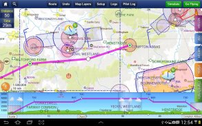
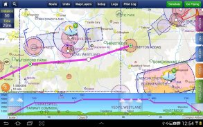
- SkyDemon အားနည်းချက်ကိုဇယားမှာ dynamic လေပိုင်နက် clipping နှင့်မြေပုံအလွှာ၏ရှေးခယျြမှုနှင့်အတူသငျသညျအစဉျအမွဲကိုသုံးပါလိမ့်မယ်အရှင်းလင်းလေကြောင်းသိပ္ပံဇယားဖြစ်ကြ၏
- လမ်းကြောင်းစီမံကိန်းရေးဆွဲခြင်းဆက်တိုက်အမှတ်များထိခြင်းနှင့်အပြောင်းအလဲများလုပ်ဆွဲသကဲ့သို့ရိုးရှင်း
- Virtual Radar သင့်ရဲ့လမ်းကြောင်းလေပိုင်နက်, မြေပြင်အနေအထား, ပိတ်ဆို့ခြင်းများနှင့်အခြား features တွေကိုမှပြောပြတယ်ဘယ်လိုပြသထားတယ်
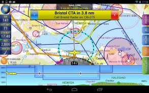
- ရှေ့ပြေး Log in ဝင်ရန်စက်ရုံအမှန်တကယ်လေတိုက်ဒေတာမှခေါင်းစဉ်နှင့် groundspeeds တွက်ချက်နှင့်အသုံးဝင်သောကြိမ်နှုန်းကိုပြသ
- သက်ဆိုင်ရာလေယာဉ်ကွင်းအဘို့အဟင်းပွဲများနှင့်အခြားစာရွက်စာတမ်းများကိုသင်စီစဉ်ထားအဖြစ်ကိုအလိုအလျောက်ပြသနှင့်များစွာသောလေယာဉ်ခရီးစဉ်အတွက်အသုံးပြုရန် georeferenced ရရှိနိုင်ဖြစ်ကြ၏
- အလိုလိုဒယ်အိုး, မြေပုံရှင်းလင်းပြတ်သားသို့မဟုတ်စာသားရှင်းလင်းပြသားသောအဘယ်သူမျှမဆုံးရှုံးထောက်ခံမှု pinch နှင့်လှည်
- ကိုတိုက်ရိုက်လေယာဉ်အသွားအလာ controller စဖို့သင့်လမ်းကြောင်းများအတွက် VFR flightplan File
- အလိုအလျောက် TAF, METAR နှင့် SIGMET ရှင်းလင်းသင်သော graphical ဒီကုဒ်ဒါနှင့်အတူတစ်လမ်းကြောင်းစီစဉ်အဖြစ်
- မိုးရေချိန်ဒေတာအချိန်ကျော်မိုးရေချိန်၏လမ်းကြောင်းသစ်ဖြင့်ကာတွန်းနှင့်အတူအဓိကမြေပုံပေါ်တွင်မွမ်းမံနိုင်ပါတယ်
- ဆွစ်ဇာလန်, သြစတြီးယား, ဆလိုဗေးနီးနှင့်ခရိုအေးရှားဘို့ GAFOR လမ်းကြောင်းခန့်မှန်းချက်များပေါင်းစည်းရေး
- ကျဉ်းမြောင်း-လမ်းကြောင်းနှင့်နယ်မြေနှစ်ဦးစလုံး NOTAM တင်ပြချက်ရရှိနိုင်ပါကသင်သည်စီစဉ်အဖြစ် updated
- ပင်မမြေပုံပေါ်တွင်အဆင့်မြင့် NOTAM သော graphical အနက်နှင့်ပုံဖော်တင်ဆက်
- အလွယ်တကူအမျိုးမျိုးသောတင်ပြချက်မှသင်၏ PLOG နှင့် output ကို print ထုတ်
- ကိုမှန်ကန်အချိန်အတွက်ပြင်ဆင်မွမ်းမံသင်တို့ပြေးဖို့လေပိုင်နက်နှင့်အခြားအလားအလာအန္တရာယ်များများအတွက်သတိပေးချက်များ,
- လေယာဉ်ကွင်းအဒ်မင်ပြန်ကြားရေးကျွန်တော်တို့ရဲ့ဇယားအတွက် featured လေယာဉ်ကွင်းအဘို့အအသုံးဝင်သောအဆက်အသွယ်များနှင့်အခြားအသေးစိတ်အချက်အလက်များကိုပြသထားတယ်
- ခန့်မှန်းချက်လေတိုက်နှုန်းဒို့အရေးကိုအလိုအလျောက်လေယာဉ်သည်အချိန်ထုတ်ယူနှင့်မြေပုံပေါ်တွင်ပြသကြသည်
- သင်အသုံးပြုတစ်ခုချင်းစီကိုလေယာဉ်ပျံများအတွက်အဆင့်မြင့်လေယာဉ်ခရီးစဉ်စွမ်းဆောင်ရည်ပရိုဖိုင်းကို Create
- ATS လမ်းကြောင်းများ mode ကိုအဲယားဝေးတစ်လျှောက်လေယာဉ်ခရီးစဉ်တစ်ခုကအခြားရွေးချယ်စရာဇယားတင်ဆက်မှုကမ်းလှမ်း
- လေယာဉ်ခရီးစဉ်ကုန်ကျစရိတ်အပါအဝင်တိကျမှန်ကန်သောလောင်စာ, အလေးချိန်နှင့်မှန်သောချိန်ခွင်တွက်ချက်မှု
- အသုံးပြုသူ-သတ်မှတ်ထားတဲ့အမှတ်တစ်န့်အသတ်အရေအတွက် Create
- သားစဉ်မြေးဆက်အဘို့သင့်လမ်းကြောင်းသစ်လုံး Analyse
- ခြောက်ခုကွဲပြားခြားနားသောအားနည်းချက်ကိုဇယားစတိုင်များအကြားကိုရွေးချယ်ပါ
- စံအဖြစ်ကျယ်ပြန့်ဥရောပဇယားလွှမ်းခြုံ
GPS စနစ် Navigator အင်္ဂါရပ်များ
- လေပိုင်နက်, NOTAM, အတားအဆီး, မြေပြင်အနေအထားများနှင့်အခြားဘေးအန္တရာယ်ချဉ်းကပ်ဘို့အ Intelligent သတိပေးချက်များ
- Virtual Radar တစ်ဘေးထွက်ပေါ်မှာရှိသမျှချဉ်းကပ်အင်္ဂါရပ်များ projection နှင့်မည်သို့သင့်ရဲ့လမ်းကြောင်းသူတို့ကိုပြောပြတယ်ပြသထားတယ်
- Vector မြေပုံအလိုအလျှောက်, မြောက်ဘက်ကိုတက်အတွက်လေယာဉ်အောက်ပါအတိုင်းထခြေရာခံသို့မဟုတ်သင်တန်းကိုဖွင့်တိမ်းညွတ်
- Clear ကိုနှင့်စုံစုံတူရိယာသင်လေယာဉ်စာရင်းဇယားများပြသနှင့်လမ်းကြောင်းမှန်ပေါ်ပေါ်တွင်သင်စောင့်ရှောက်ကူညီ
- တစ်ဦး HSI / ILS တူရိယာသင်သည်သင်၏စီစဉ်ထားလမ်းကြောင်းမှစောင့်ရှောက်ခြင်းနှင့်ချဉ်းကပ်ဘို့စောစောထတန်းကူညီပေးသည်
- တိုက်ရိုက်ရှေ့ပြေး Log in ဝင်ရန်သင့်လက်ရှိအနေအထားအပေါ်အခြေခံသင့်ရဲ့လမ်းကြောင်း, ETAs, Atas နှင့်အသုံးဝင်သောကြိမ်နှုန်းအားဖြင့်တိုးတက်မှုပြသထားတယ်
- လျင်မြန်စွာလုံခြုံဒေသများတွင်ဖော်ထုတ်ရန်သင်တို့ပတ်လည် TerrainSafe သည် dynamically အရောင်များတောင်တန်းမြေပြင်အနေအထား
- တိုက်ရိုက်စေရန်အနီးအနားမှာလေယာဉ်ကွင်းတစ်ရွေးချယ်ရေးမှကောက်နေသဖြင့်တစ်ဦးလျင်လွယ်ကူ Re-routing ကိုခွင့်ပြု
- ချဉ်းကပ်ပြန်ကြားရေးလေယာဉ်ပြေးလမ်းကားချပ်, TAF, METAR, NOTAM နှင့်တစ်ဦးချဉ်းကပ်မှုအောင်များအတွက်အသုံးဝင်သောအခြားလေယာဉ်ကွင်းအသေးစိတျဖျောပွသညျ
- ဆက်စပ်နေသောသတိပေးချက်နှင့်အတူ TAF နှင့် METAR ၏တိုက်ရိုက် updates တွေကိုပြေးစဉ်, *
- တိုးချဲ့လေယာဉ်ပြေးလမ်း centrelines သင့်ရဲ့ဦးတည်ရာကိုလေယာဉ်ကွင်းအနီးကသငျသညျအဖြစ်မြေပုံပေါ်တွင်အလိုအလျှောက်ပေါ်လာပါ
- အနေအထားအစီရင်ခံဘို့အနီးဆုံးလူသိများတဲ့အမှတ်များဖို့အနေအထားဆွေမျိုးများ၏အမြဲတမ်း Display,
- ထိနဲ့ဆွဲအားဖြင့်လေယာဉ်ခရီးစဉ်အတွက်နေစဉ်စီစဉ်ထားလမ်းကြောင်း၏လွယ်ကူသောပြောင်းလဲ
လေယာဉ်ခရီးစဉ်အတွက်စဉ်အသက်ရှင်သောရာသီဥတု update ကိုများအတွက်လိုအပ်သော * အင်တာနက်ဆက်သွယ်မှု
SkyDemon - ဗားရွင္း 4.0.2
(28-01-2025)SkyDemon - APK သတင္းအခ်က္အလက္
APK ဗားရွင္း: 4.0.2package: aero.skydemon.skydemonandroidSkyDemon ၏ ေနာက္ဆုံးဗားရွင္း
အျခား ဗားရွင္းမ်ား


က႑တူအက္ပ္မ်ား

သင္ႏွစ္သက္ႏိုင္သည္မ်ားမွာ...


